
The Black River near Fort Apache, Arizona streamflow gage was a great memory (larger view - 490Kb). It was always an adventure going in and coming out the backcountry road on the Fort Apache side of the Apache Indian Reservation. And it was one of those gages I didn't necessarily like doing the work but always liked afterward.
So are gages a love-hate relationship for streamgagers? For many streamgagers and their many gages, yes. And this gage was the best at the extremes of my love-hate relationship with my field work.
The gage is about 30 miles south-southwest of the town of White River, on the dirt road past the gravesite marker for Geronimo off highway 73. You're on the high Natanes Plateau where the land is flat and only broken by the entrenched river valleys and the low mountain divides. From the highway you head south to the White River valley where you have to watch out for packs of feral dogs. After coming out of the White River basin you go into the Black River basin.
The road is on the clay layer in the rock layers so driving in severe winter rain and snow storms become a nightmare where even in 4-wheel drive it can slide off at 5 mph. In addition as you drive down the divide into the Black River valley the road dips into the flood zone, so you can drive all the way but the last 3 miles where you can see the gage but you can't get to the gage because of the 3-6 feet of water over the road.
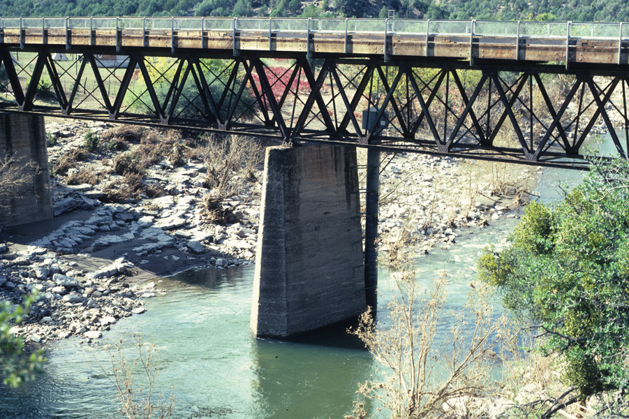
And even when you can get to the gage, as you can see in the photo of the gage, you climb over the bridge rail and down the ladder to the small 3x5 foot platform, which is about 30 feet above the river. In addition, to check the inside and outside water level you climb down the ladder on the outside downstream side of the gage. This is ok for most flows, but during high flows, and the river is about 20 feet deep and rushing by your feet at tremendous velocities, it's just a little scary.
One time I had to get in to service the gage and make a measurement following the early October 1983 flood peak. I couldn't get into the gage the first time as the river was over the road. I could the next day, but discovered the flood was so high it ripped the cable car from the cable way which had be broken into by vandals and released into the center (something they did routinely). Only the support bars and pulleys where left dangling from the cable.
In addition, the water had gotten so high it washed out the base of the left bank A-frame and made any measurement impossible until the whole measuring cableway could be repaired. We did a slope-area measurement in the following weeks, see the peak streamflow listed for the gage (above link to gage data). We later discovered the riffle just below the gage had moved upstream above the gage and bridge.
Once all the work was done, I checked the historical record and discovered the riffle which controls the gage-height (gage pool) migrated from below the gage to above the gage and back in 20 years cycles. The river channel after the flood was almost identical to the photos taken in the early 1960's. Such is real-world hydrology.
And the real event at this gage? Well, among others one comes to mind. I had to do some maintenance which required two people. For some reason I can't remember why we took the other technician's van. When we finished the work we decided to take a short cut out to the highway back to Globe and Phoenix. This back road starts at the gage and winds south and west through the San Carlos half of the reservation to highway 60. Or so we thought.
It's a reasonable good road, with only some rough or slippery spots in stormy weather. But driving down into a small creek valley with a 180 degree turn, I drove down and then up and out of the valley when I suddenly heard the feared sound, "Psssttt", of a flat tire. I was halfway of the hill when it went totally flat. We couldn't change the tire on the hill so I slowly back down the to the curve. Then I heard a second feared sound, "Psssttt", as I discovered I ran over the same thing a second time.
Now both left side tires were flat and we only had one spare tire. We weighed our options and it was clear. Remember this is before cell and satellite phones. So we walked seven miles to highway 60, except about half way out it started to rain, and it rained the rest of the way to the highway where we hitched a ride to Globe. Needless to say, you can have a good conversation with someone walking seven miles in the rain.
It was near midnight when we got to Globe, so we got rooms at a motel and in the morning called the office to get approval to hire a tow truck to retrieve the van. From the rain though, the tow truck almost didn't get past the first mile as the road was so slippery he barely kept it on the road. But he did and we got the van out and back to a tire dealer. It was into the evening when we arrived back.
In the end, despite the love-hate relationship for this gage, it actually was one of my favorite gages. You spent a day in the remote areas of the reservation which had seen the history of the Indian wars, establishiment of reservations and Indian resettlements, and the operation and management by the Tribe. Much of the land hadn't changed, only the management of the land for timber harvesting and open range for cattle, horses, and ever-present feral pets.
And stopping in the town of White River it was always interesting to see how indians manage and operate reservation facilities, and how Apaches treat other (non-Apache) indians. While it's nice to think all indians and treat other indians equally, they don't. They're not necessarily as bad as white or other minorities, but there is a hierarchy with and within any Tribe and tp other Tribes.
And how so? Well, all the managers where Apaches, but none of the restaurant and motel staff were Apaches, but other Tribes. All the cashiers at the grocery and other stores were Apaches, but all the workers other Tribes. But the reality was that all the top managers below the Tribal council and senior management were non-indians. There was a reason for this as I learned from one of them.
It seems in the past Apache Tribe had different major and minor sub-tribes, some were allies and some enemies of other sub-tribes and of other Apaches on other reservations. It's why the reservation has the White River and San Carlos halves run by separate councils. But over time these differences faded and Apaches treat other Apaches almost equally, which means the consider all Apaches family.
And being family an Apache can't say no, meaning jobs, help, etc. Over time the Apaches found their beauracy bloated with many "family" members, so much so they were going broke in the commericial ventures in timber, sport hunting and fishing, cattle and horse management, and so on. So they hired white managers to fire people and keep the jobs to the minimum.
The nearly two years I had this field trip was an interesting experience. With all it's good and bad, and driving - where 75-80% of the time in the field was driving even when I stayed the whole week in Pinetop just outside the reservation - I would do it again. So that's my story for this gage, this time as memory serves.

Thank you for your wonderful writuep on that gage. I just happened to stumble onto your story via a very odd route. I am so glad I found it and your blog. I have some experience with that Rez and you are so "right on." Also some experience with stream flow gages and your story is just awesome. Thank you for taking time to write it up and post it where it can be found.
ReplyDelete