Ok, it's a "Huh?" Well, not really, and you can insert any profession or endeavor for streamgaging and relate it to photography. Just for me though, it's streamgaging. I spent 13-plus years streamgaging in Oregon, Arizona and Washington. I thoroughly enjoyed it, and although many days weren't so enjoyable then that's the reality of it and my history.
I wouldn't change or trade it, which, if you can say that, is one of the few great things in one's life. To get to the end and realize it was worthwhile and fun. When I started I had the great fortune to learn from two senior technicians whom each handed me their different generation of knowledge and experience. I have always been grateful to them for my first years of learning the basics and finding the enjoyment of streamgaging.
One of the technicians was from the 1950's generation. He started in the Bureau of roads surveying in several of the highways in western Oregon before transferring to the USGS. He was hired when techicians did the basic job of maintaining river and lake gages and do the field work servicing them. They later taught them to produce and review streamflow data. I can't begin to recount the field work we shared.
The other one was from the 1960's generation and the one who really taught me streamgaging. He started in the northern California office when the Redwoods Park controversy was raging. He taught me about consistency of your field work, and meticulousness of your field notes. Both of these you don't realize the value for several years when you've found they're embedded into your work psyche. And you see the value, not just to streamgaging, but many other things in work and life.
Which is? Streamgages, or even lake gages, are small houses with one or more stage sensors attached to one to four recorders, which in later years are attached to various telemetry equipment. There is a proceedure you go through the minute you drive up to the gage, from the initial outside work, the work inside the gage house, any discharge measurement, any necessary repairs, and the last review before leaving.
This is where being consistent, methodical, and precise is necessary. You have to service the gage(s) in the same way you do every gage, from the time you unlock the gagehouse door to the time you lock it. It's that mundane routineness that frees you to focus on the other things and think through problems you encounter while still working on the gages. On one plane you're working instinctively and the other thoughtfully.
It's the simple idea of what I always termed being awake and aware when you're standing in the gage house. And when you were done and all the paperwork completed, you had the complete satisfaction and trust you did your best and didn't leave anything undone. Your whole world for that short time was that gage house and that discharge measurement. Nothing less and nothing more.
When I was reading about large format photography, I was overwhelmed with the equipment, the process, the field work, the films and on and on. But when I got the camera in the field, I realized my training as a streamgager and focusing on the basics of the camera and lenses, the exposure and metering, the thought process of the images, and the whole thing together, it turned out far easier than I had imagined.
First, I knew the basics of photography from over 30 years as a hobby, such as light, metering, etc. so it's was a matter of sorting it out for that the image and exposure. Second, the camera and lens, even being totally different, was something to learn and work with consistently, methodically and precise. Something I did for 13-plus years. And third, the thought process is simply focusing on the work and being in the moment at that time and place.
When I got done with my first few days with the system and then when I got the film back, I discovered I wasn't as bad as I feared, but then, I could have done better, which is the reason to do it some more. And more after that. The joy of being there and photographing what I see. Thanks to Duane and Mike.
Wednesday, November 21, 2007
Sunday, November 18, 2007
Colorado R at Lees Ferry
 photo copyright Brian J. McMorrow
Since the first half of my career with the USGS was as a streamgager, and while I did a lot of other field work, servicing streamflow gages and making discharge measurements and the subsequent office work to produce the real-time data for the Web and the annual data report data, much of my best memories are from times in the field. That's because you're where the real world of hydrology is and where you are in the world. Not sitting in an office being a scientist, but around rivers where it happens.
Well while I was in the Phoenix office, the USGS was contracted to study the sediment transport and deposition on the Colorado River below Glen Canyon Dam as part of a government inter-agency task force to see if the lower Colorado River regime could be restored as the years of clear water had eroded numerous beaches and redefined the hydrology of the river. The Flagstaff and Phoenix field office chiefs realized the study was to begin without anyone doing some initial data collection before the releases were to begin.
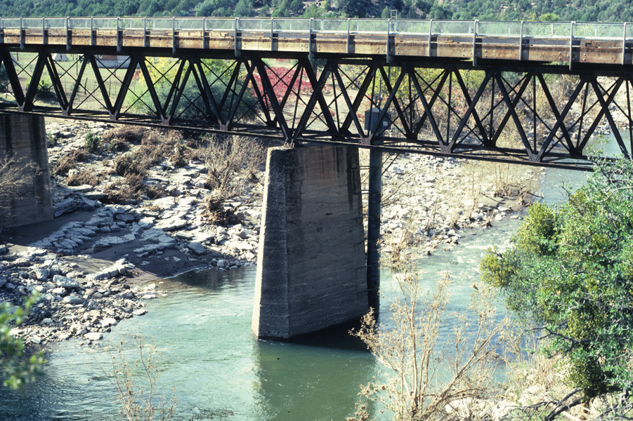
To resolve that they dispatched another technician and I to the Colorado River at Lees Ferry gage for the period leading up to the start of the study, meaning about two weeks or less depending when the study crew showed up from Flagstaff. This gage is just downstream from the starting point for the rafting trips down the Colorado River, see a photo with the gage on the opposite bank (tall concrete house - access and measuring cable just upstream, not visible in photo).
Well, for those who haven't driven to Lees Ferry from Phoenix, it's about a 5-6 hour drive. Driving north from Phoenix you venture in and out of the Verde River valley before getting up on the Mogollon Plateau into Flagstaff, going from about 1,500 feet to over 7,000 feet at Flagstaff. You drive through Flagstaff north to Page. It's all down hill from Flagstaff, often straight for miles and miles. The only stops are along the Navajo Reservation towns.
Just south of the Colorado River the highway splits to Page and to the Grand Canyon. We stayed in Page the first night before going to the gage the next day. Our job was to measure and take sediment samples twice a day. It's about a 4 hour job to do this as you measure on the way over to the gage, service it, and sample on the way back. With the equipment setup and takedown, it consumes a morning and an afternoon each time.
On the first day we went to Marble Canyon for lunch. Then it was a town if you stretch your imagination to include a small motel, restaurant, store, and gas station along with a few tourist shops because it's on the highway from Page to the North Rim of the Grand Canyon and on to southern Utah. In short, it was a wide spot in the road. But we liked it so much we went back to Page, cancelled our room and stayed at the motel.
What we liked most of all was the area around it. The Vermillion Hills were beautiful in the evening. And there was the bridge, the desert, and the small roads to check out. No one questions workers in government trucks on back roads. So we had a great time, and although the work as routine, we liked watching all the boats leave the launch site in the morning and paddle or power underneath the cable while we worked. And watch them setup in the afternoon for the next day's launch.
Well, it was memorable for just being routine and magnificant too. It's the adage I tell folks about streamgaging. We got paid to go, stay and work in places people go on vacation, and pay to stay. And we contribute to the study of the nation's rivers. What's not to like about that?
Thursday, November 15, 2007
Black R nr Fort Apache

The Black River near Fort Apache, Arizona streamflow gage was a great memory (larger view - 490Kb). It was always an adventure going in and coming out the backcountry road on the Fort Apache side of the Apache Indian Reservation. And it was one of those gages I didn't necessarily like doing the work but always liked afterward.
So are gages a love-hate relationship for streamgagers? For many streamgagers and their many gages, yes. And this gage was the best at the extremes of my love-hate relationship with my field work.
The gage is about 30 miles south-southwest of the town of White River, on the dirt road past the gravesite marker for Geronimo off highway 73. You're on the high Natanes Plateau where the land is flat and only broken by the entrenched river valleys and the low mountain divides. From the highway you head south to the White River valley where you have to watch out for packs of feral dogs. After coming out of the White River basin you go into the Black River basin.
The road is on the clay layer in the rock layers so driving in severe winter rain and snow storms become a nightmare where even in 4-wheel drive it can slide off at 5 mph. In addition as you drive down the divide into the Black River valley the road dips into the flood zone, so you can drive all the way but the last 3 miles where you can see the gage but you can't get to the gage because of the 3-6 feet of water over the road.
And even when you can get to the gage, as you can see in the photo of the gage, you climb over the bridge rail and down the ladder to the small 3x5 foot platform, which is about 30 feet above the river. In addition, to check the inside and outside water level you climb down the ladder on the outside downstream side of the gage. This is ok for most flows, but during high flows, and the river is about 20 feet deep and rushing by your feet at tremendous velocities, it's just a little scary.
One time I had to get in to service the gage and make a measurement following the early October 1983 flood peak. I couldn't get into the gage the first time as the river was over the road. I could the next day, but discovered the flood was so high it ripped the cable car from the cable way which had be broken into by vandals and released into the center (something they did routinely). Only the support bars and pulleys where left dangling from the cable.
In addition, the water had gotten so high it washed out the base of the left bank A-frame and made any measurement impossible until the whole measuring cableway could be repaired. We did a slope-area measurement in the following weeks, see the peak streamflow listed for the gage (above link to gage data). We later discovered the riffle just below the gage had moved upstream above the gage and bridge.
Once all the work was done, I checked the historical record and discovered the riffle which controls the gage-height (gage pool) migrated from below the gage to above the gage and back in 20 years cycles. The river channel after the flood was almost identical to the photos taken in the early 1960's. Such is real-world hydrology.
And the real event at this gage? Well, among others one comes to mind. I had to do some maintenance which required two people. For some reason I can't remember why we took the other technician's van. When we finished the work we decided to take a short cut out to the highway back to Globe and Phoenix. This back road starts at the gage and winds south and west through the San Carlos half of the reservation to highway 60. Or so we thought.
It's a reasonable good road, with only some rough or slippery spots in stormy weather. But driving down into a small creek valley with a 180 degree turn, I drove down and then up and out of the valley when I suddenly heard the feared sound, "Psssttt", of a flat tire. I was halfway of the hill when it went totally flat. We couldn't change the tire on the hill so I slowly back down the to the curve. Then I heard a second feared sound, "Psssttt", as I discovered I ran over the same thing a second time.
Now both left side tires were flat and we only had one spare tire. We weighed our options and it was clear. Remember this is before cell and satellite phones. So we walked seven miles to highway 60, except about half way out it started to rain, and it rained the rest of the way to the highway where we hitched a ride to Globe. Needless to say, you can have a good conversation with someone walking seven miles in the rain.
It was near midnight when we got to Globe, so we got rooms at a motel and in the morning called the office to get approval to hire a tow truck to retrieve the van. From the rain though, the tow truck almost didn't get past the first mile as the road was so slippery he barely kept it on the road. But he did and we got the van out and back to a tire dealer. It was into the evening when we arrived back.
In the end, despite the love-hate relationship for this gage, it actually was one of my favorite gages. You spent a day in the remote areas of the reservation which had seen the history of the Indian wars, establishiment of reservations and Indian resettlements, and the operation and management by the Tribe. Much of the land hadn't changed, only the management of the land for timber harvesting and open range for cattle, horses, and ever-present feral pets.
And stopping in the town of White River it was always interesting to see how indians manage and operate reservation facilities, and how Apaches treat other (non-Apache) indians. While it's nice to think all indians and treat other indians equally, they don't. They're not necessarily as bad as white or other minorities, but there is a hierarchy with and within any Tribe and tp other Tribes.
And how so? Well, all the managers where Apaches, but none of the restaurant and motel staff were Apaches, but other Tribes. All the cashiers at the grocery and other stores were Apaches, but all the workers other Tribes. But the reality was that all the top managers below the Tribal council and senior management were non-indians. There was a reason for this as I learned from one of them.
It seems in the past Apache Tribe had different major and minor sub-tribes, some were allies and some enemies of other sub-tribes and of other Apaches on other reservations. It's why the reservation has the White River and San Carlos halves run by separate councils. But over time these differences faded and Apaches treat other Apaches almost equally, which means the consider all Apaches family.
And being family an Apache can't say no, meaning jobs, help, etc. Over time the Apaches found their beauracy bloated with many "family" members, so much so they were going broke in the commericial ventures in timber, sport hunting and fishing, cattle and horse management, and so on. So they hired white managers to fire people and keep the jobs to the minimum.
The nearly two years I had this field trip was an interesting experience. With all it's good and bad, and driving - where 75-80% of the time in the field was driving even when I stayed the whole week in Pinetop just outside the reservation - I would do it again. So that's my story for this gage, this time as memory serves.
Monday, November 12, 2007
Gray Creek nr Oakridge

The title and image don't match? Well, let me explain, as this photo, taken in 1979 shortly after I started working for the USGS in Eugene, Oregon, has a connection to my work and my life. We installed the gage and stated collecting data on Gray Creek in July 1978 and operated it to October 1986. The gage was part of my field trip in 1978-79 and 1981-82.
The gage was on a small creek on the south side of the Willamette River along Highway 58 a few miles west of Oakridge (map). Access was on a one lane logging road off Highway 58 used by log trucks hauling logs out of the Willamette National Forest. The gage was just below a one lane bridge made entirely of large logs. We parked at the turnout for the bridge and serviced the gage on the left bank.
We made our measurements by wading at the gage. It was a fairly good cross-section about 6-8 feet wide and <1-2 feet deep for most measurements. Highwater measurements could be made from the log bridge when log trucks weren't using it, but you could usually wade the creek anywhere from a few feet to a few hundred feet downstream where the creek went around a bend and spread out into a wider creek.
The creek above the gage made a 90-degree bend and went almost due south into the headwaters. About a few hundred feet above the bend a giant (about 4 foot diameter) Douglas Fir tree had fallen across the creek, leaving an 8 foot gap between the creek and the lowest part of the tree. Over time, storms had washed other trees downstream which got caught into a logjam, along with rocks that rolled along the bed. It was a small, naturally made dam.
When I first saw and explored it one summer day there wasn't a lake behind it, it had filled with rocks, trees and debris collected over the years and the creek level was at the top of the debris and over the Douglas Fir tree holding everything up. All the storms up until then hadn't managed to dislodge anything and just kept adding to the debris in the logjam behind the tree. And so we thought our gage, protected by the log bridge, was safe.
In December 1981 we experienced several major storms in the Willamette River valley and the tributary basins. Then we got a phone call from the Forest Service folks asking if we had been to the gage. They hadn't been to the gage to check their sediment gage, but residents in the area heard a number of really loud sounds overnight coming from the upper creek valley. And being my gage, it was my job to check it out.
When I drove around the last bend I knew something was terribly wrong. The log truck bridge was severly damaged. The length of the creek and creek bed from the upstream bend past the downstream bend was filled with lots of rocks. Not small cobbles. Big and really big rocks. And while the gage was there, protected by the bridge, it was leaning downstream, had some dents in it, and was surrounded by the those big rocks with all the dirt gone.
There weren't any highwater marks to do an indirect there, and two weeks later, in the middle of a snowstorm we did an indirect a few hundred feet upstream of the highway some distance downstream from the gage. That was also an experience I won't forget (try finding a white survey level rod in a snowstorm through a surveyor's level/scope). But the real story was upstream of the gage.
After servicing the gage and make a new measurement, I hiked upstream around the bend. And not much to my surprise but really to my amazement, the entire logjam was gone. Completely. And the creek was then in the original channel before the logjam began to collect material and debris. It was a normal creek again. And the giant Douglas Fir was also gone, presumably broken into pieces and gone downstream. Such is the real world of hydrology. It's not sitting in the office, but in the field standing in creeks and rivers.
The other thing this gage taught me was measuring a creek. Making wading measurements is fairly straight forward, but there is one basic rule to judge when you're in over your head, really over your chest waders, or under your feet. The rule is that the maximum velocity times the deepest depth should not exceed 10, and you adjust it according to your experience. Most streamgagers can wade a factor 7-8 easily but over 9, it's becomes difficult for most normal size men, and above 10-11, you either better be big or tall.
This factor is adjusted when the maximum velocity and deepest depth in the same place, same vertical profile, in the creek, meaning the creek is at its highest energy at that point in the cross-section, which means during storms events, the energy is moving the bed material. You normally lower the factor by one or two to be safe. But sometimes you're faced with the choice of trying or not getting a critical measurements.
Well, one winter storm on Gray Creek I was faced with this issue. I really wanted to make a measurement but the flow was high for the creek. And being a new streamgager wanted to show I could do it. When you make a wading measurement, you have to first wade across the creek to set the tagline, then wade back, and then get the equipment to make the measurement, wading across and back again.
Well, about halfway across to set the tagline, I got stuck. I simply could not move. I was standing parallel to the flow using my wading rod for support as I tried to move each foot. The flow was so fast I had a standing wave on the front (upstream) side of my body like the bow of a ship. The velocity was so fast the rocks on the bed were moving and taking my feet downstream. I knew if i lost my balance, I would be gone downstream, part of floating debris in the flow.
Well, while standing in the middle of the creek with storm water flowing swiftly by and using my wading rod to just stand there while slowly sliding downstream, I thought of John Muir. And this is a really big, "Huh?" Well, John Muir wrote about hiking up a canyon in the Sierra Mountains once when he faced a vertical rock wall with the choice to climb it using a gap in the rock to the top or hike back down.
He chose the gap and began climbing, until he suddenly found the crack just as wide as the length his body from his shoulders to his feet. If it got wider he would fall, and he couldn't use his body to go back down. He was stuck with several hundred feet of air between him and the base of the rock face. He paused for sometime before he continued upward as the gap didn't widen. He realized his luck and his stupidity.
Anyway, I decided to waddle my way across, thinking if it got worse I could simply let go and float downstream or it would get better. It got easier to make it to the other bank. I set the tagline and waded back across, very slowly, sliding and waddling with my feet. And then I did it all over to get the measurement and release the tagline. I finished the day servicing the gage and calculating the measurement to drive home. Except two things.
One the measurement had a factor 12 and at the same point in the cross-section. I just sat there wondering what the hell I was thinking. And two, the photo. While I was catching my life again, I walked around the area. Since I often took my camera with me to take photos of the gages, work and just being in places few people go. I saw the leaf on the rock and took the photo. It was dark (overcast sky and deep in the creek valley), and had to use a slow shutter speed without a tripod.
I forgot about it until I got the slides back. Somehow it touched me as it still does. I had a print made then and another about 10 years ago with a professional print lab. It hangs by my desk as a reminder of our life. And so the photo became a personal story and feeling. The ephemeral and the eternal. Aren't we all the sum of each?
Saturday, November 10, 2007
Willamette R nr Oakridge
Ok, while I'm on streamgaging - hey I spent 13 years streamgaging in Oregon, Arizona and Washington - I'll talk about another gage, another time. Quite the opposite for a winter field trip. The Willamette River near Oakridge. It's on the same river as the Dexter gage but this one is above the reservoirs, and used to measure the inflow into the reservoir.
The gage is just off Highway 58 from Eugene to Oakridge, just past the halfway mark up the Middle Fork Willamette River valley, and often where the weather changes from the Willamette Valley (Eugene to Portland) to the river valleys. It always was the last gage on the field trip where I stayed in Oakridge for a few night to head back to the office. It was a nice trip ending gage. It wasn't an easy one, just an enjoyable one.
The gage and cableway has easy access and is easy to service. The cableway is about a 350 foot span about 40 feet or so over the river. You release the cable car on the left bank (facing downstream) to glide over the river to the right bank and begin the measurment. It's not unusual to get cold and rainy weather, but mostly the valley in the immediate area seemed to trap the warmer air so you may be cold but didn't freeze (your whatevers).
Well one day on the way back, it didn't seem all the cold, on the edge of rain or snow with a thick cloud layer. I serviced the gage and set up to measure the flow. I released the car and flew over the cable to the other side - something I always thought was the coolest feeling, free gliding over a river in a small car. When I got the right bank location, I lowered the weight and meter to start the measurement.
Measuring the flow is a fairly straight-forward effort. While keeping track of your distance to get the section and total width, you measure the depth of the water and velocity of the flow at selected places in the vertical profile. That's the science part of the work. The art of it is the on-going calculation to get 4-5% of the total flow in each of about 24 sections. My experience is that this is a skill you innately learn or not.
While on this day, as I began to measure I felt the temperature drop. Since you bundle up anyway to stay warm - after all you're sitting in a wooden car for one to one and a half hours - it's not hard to just zip the raincoat a little more. The more I measured the colder it felt. And then, in a moment, everything changed. It took away my concentration on measuring.
I looked up and noticed huge snowflakes slowly and quietly gliding down. All around. The whole sky was filled with slowly falling snowflakes, the biggest one I've ever seen in my life. Suddenly the whole world was silent. Like all the snowflakes absorbed all of the sound in the world, except for the sound of their falling. I could barely see beyond a few dozen feet except the faint view of the hills and the river.
I stopped my work and just sat there. I lost a sense of time, and even place, watching the sky with huge snowflakes filled the air around me. They slowly settled on everything, near and far, including the roof of the car and the two seats of the car. There was little wind so the snowflakes just fell, and a few into the car. I held my hand out and watch as it filled with the light snowflakes. They weren't cold, just snowflakes.
I don't know how long I watched and listened to the silence. I know I had to get back to work, and get on back to Eugene, but even after I finished the measurement I just stood on the bank of the river feeling the wholeness of the time and place. I've never had a similar experience, and doubt I ever will. Being overe the river in the valley all alone with the world, and in the midst of a sky filled with snowflakes and silence.
And they say streamgaging isn't fun.
Friday, November 9, 2007
Willamette R nr Dexter
I was reading the Tao of Pooh by Benjamin Hoff about the story of the three men tasting a sample of vinegar. And this relates to the USGS streamflow gage? In way. It's about feelings, and anyne who finds vinegar a bad experience could relate.
I worked for the USGS in the Eugene, Oregon office from 1978-82, where I started with the USGS as a hydrologic technician. The USGS assigns field work by streamflow gaging networks. In my first year I was assigned the Middle Fork Willamette River and Mohawk River. The network had about 15 gages which were serviced every 6-8 weeks and in between based on events, such as floods.
One of those gages was the Willamette River near Dexter, the first gage below the larger reservoirs on the Middle Fork Willamette and the last tributary before merging with the Coast Fork Willamette River and flowing through Eugene. The gage was built post World War II in preparation for the three upstream reservoirs. It's on private property with a big field behind the house down the hill to the gage on the river.
We used to move the goats to the gage so they would eat the bushes while we did our normal annual maintenance work at the gage. We only had to remember to keep them from getting near the trucks as they liked to eat whatever paper and other stuff that was easily accessible to them. Remember goats aren't picky, but they sure did eat blackberry bushes very well. Ok, so why the connection to vinegar?
Well, in the winter the area was in a valley where cold air settled and the temperatures dropped well below freezing. This wasn't so much of a problem when measuring the flow from the cableway suspended over the river (which was at the gage just downstream). The measurement took just over an hour and during the whole time you were sitting in a small cable car measuring and writing everything down.
If you were there on the wrong day, the wind would blow up the river, and you could see the waves of freezing fog move toward you, usually every 5-10 minutes. The cold would go through you and chill you to the bone. And then deposit a layer of ice on the windward side of your coat, rainpants and hat. You couldn't hide from it. You couldn't even hunker down. It simple overwhelmed you, went through you, and moved onward up the river.
After the hour-plus time over the river, you would be colder than you've ever felt. You would sit in the truck with the heater going for 15-20 minutes just to start moving again before you continued the field work. It was a lesson in being. I used to really hate going there in the winter, but one time I decided to turn it around. I remembered my worst day measuring the flow, the day I was covered in ice and felt so cold I could barely move.
That became the standard, and any day after that I thought was bad, I would think if it was worse. If it wasn't I would be happy knowing I've survived worse. And if it was close, I would ask if it was a new standard, because if it was, then I've set a new standard, a new cold I could survive. It never was than the worse day at the Dexter gage, but to this day it's still there in my memory as the worst day of field work I've ever had.
The whole situation about the Dexter gage showed me the relativeness of life and the control everyone has over the perspective they have to any situation. I loved streamgaging and had a lot better days, even in the winter (another story), and looking back the worst day was still good to remind me about living and being. And walking away at the end of the day with a smile.
And I learned to always bring a really big thermos of hot coffee.
Subscribe to:
Posts (Atom)
